
Topographical surveys stand as a fundamental element in the world of construction, environmental planning, and land development. These surveys provide a detailed and accurate depiction of the natural and man-made features of a piece of land, along with its elevations and contours.
If you’re eager to know more on the subject, bellow we’ll dive into the significance of topographical surveys, the role of surveyors in this process, and how these surveys are instrumental in various projects.
Understanding Topographical Surveys

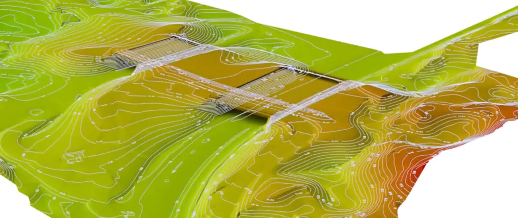
A topographical survey, often referred to as a land survey or a contour survey, is an essential process that maps the different elevations and features of a parcel of land. It provides a three-dimensional view of the land, showing all natural and man-made objects, including hills, valleys, trees, buildings, streets, utility poles, and manholes. Discover more on this link https://www.intelligentliving.co/the-importance-of-topographic-surveys/.
The primary purpose of a topographical survey is to gather spatial data about the land’s characteristics and its relative heights.
This type of survey is crucial in the initial planning and design phase of any construction or land development project. It helps architects, engineers, and planners to understand the landscape and design buildings, roads, or other structures in harmony with the existing environment. The data from these surveys guide decisions about the placement of buildings, the need for grading, and the layout of utilities and roadways.
Role of Surveyors in Topographical Surveys
The process of conducting a topographical survey is intricate and requires a high level of precision and expertise, typically carried out by professional land surveyors. These specialists use a variety of tools and technologies for the purpose of decoding the landscape, among other tasks.
Traditional tools include theodolites, levels, and measuring tapes, while more advanced technology like GPS (Global Positioning System), EDM (Electronic Distance Measurement), and laser scanning are increasingly used for greater accuracy and efficiency.
Surveyors begin by establishing a network of control points around the survey area. These points serve as reference locations for all measurements taken during the survey. Surveyors then measure the distances, angles, and elevations between these control points and various features on the land. These measurements are often supplemented with aerial photography and satellite imagery, providing additional context and detail.
The data collected is then processed and transformed into detailed maps and drawings, usually using specialized CAD (Computer-Aided Design) software. These maps not only show the elevations and features of the land but also include detailed annotations and symbols that provide additional information about each element.
Applications and Benefits of Topographical Surveys
Topographical surveys are indispensable in a wide range of applications. In construction, these surveys are the foundation upon which all design and planning are based. They ensure that engineers understand the characteristics of the land, leading to more efficient and safe designs.
For instance, understanding the slope of the land is crucial for drainage planning and the foundation design of buildings.
In environmental planning, topographical surveys help assess the impact of proposed developments on the environment. They are used to identify flood-prone areas, plan drainage systems, and manage land effectively for environmental conservation.
For infrastructure projects like road construction, topographical surveys provide critical information about the land’s gradient and existing obstacles, which is essential for designing efficient and safe road networks. They also play a crucial role in the planning of utilities like water, gas, and electricity, ensuring that these services are laid out in the most practical and least intrusive manner.
Topographical surveys also find applications in mining, where they are used to map out the topography of mining areas and plan the extraction process. In agriculture, these surveys assist in the planning of irrigation systems, land leveling, and crop planning. Check out this page.
Accuracy and Legal Implications
The accuracy of a topographical survey is of utmost importance, as even small errors can lead to significant issues in planning and construction. Inaccurate surveys can result in structural problems, legal disputes, or environmental damage. This is why the role of the surveyor is so critical, and why professional standards and regulations govern surveying practices.
In legal contexts, topographical surveys can be used to resolve property disputes, define property boundaries, and support planning applications and other legal documentation. They provide an accurate, detailed, and up-to-date representation of the land, which is essential for any legal examination or decision-making process related to land use and ownership.
Technological Advancements and Future of Topographical Surveys
The field of topographical surveying continues to evolve with technological advancements. Modern techniques like 3D laser scanning and drone surveys are becoming more common, offering higher levels of accuracy and detail, and reducing the time and labor required for traditional survey methods.
These technologies also allow for the capture of data in areas that are difficult or dangerous to access, such as steep terrain or dense vegetation.
The future of topographical surveys lies in the integration of these advanced technologies with traditional methods. This integration will enable more comprehensive, accurate, and efficient surveys, further enhancing their significance in various fields.