This article is an abstract of Dr. Koji IKEUCHI’s presentation who is a professor at the University of Tokyo since October 2016.
Before that, he worked at the Ministry of Land, Infrastructure, Transport and Tourism (MLIT) till June 2016. As a civil engineer of the MLIT, He was in charge of flood control measures and management of natural disasters for many years. He became the Director General of the Water and Disaster Management Bureau in 2015 and he was the Vice Minister for Engineering Affairs of MLIT in 2016, when he left.
In this symposium, He talked about the Water-Related Disasters and Disaster Risk Management in the Tokyo Metropolitan Area.
The subject of the discussion is Water-Related Disasters and Disaster Risk Management in the Tokyo Metropolitan Area. His discussion can be considered as a case study to deal with the water and flood related disasters, mitigation measures and risk management, for any metropolitan area of the world, since Tokyo, Japan is considered one of the world’s most developed city.
He started with the outline of the flood control measures in Tokyo and told that there are four water systems in Tokyo (Arakawa River, Tone River, Tama River and Tsurumi River). He said that flood control measures in Tokyo can be classified into three types namely;
1)Measures against large rivers such as Arakawa, 2) measures against small and medium rivers such as Kanda River and 3) storm surge and earthquake countermeasure of river in the lowland areas.
He showed the historical background of flood control countermeasures to reduce flood damage in Kanto area. He also presented the cross section of the downtown in Tokyo and said that urban areas are located lower than the flooding levels of the rivers and some part of the land is lower than the average sea level. Therefore, the downtown of Tokyo is an extremely vulnerable area against flooding and storm surge. About 1.5 million people are living here so embankment failure will cause tremendous damage. Further, he also talked about typhoons and said that every year, heavy rains due to typhoons are causing flooding damages. Aforementioned issues are critical one and needs to be addressed.
Talking about the measures against large rivers such as Arakawa, he introduced the Arakawa River and said that Arakawa is a class “A” river and managed by the national government. This river is flowing down the central part of Saitama Prefecture and the city part of Tokyo and poured into the Tokyo Bay.
Asakusa, Sumida, Kinshicho and other downtowns in Tokyo were inundated in 1910 due to Arakawa flood. Catherine typhoon in 1947 broke levee of Arakawa River at many points, and Saitama and Tokyo lowlands flooded at a large scale. This was the greatest flood after the Second World War.
Comprehensive flood control measures of Arakawa were started after the 1910 flood.
|
|
These measures includes; Linearization of river way and construction of cross levee to control flood flow at the middle part were carried out. Improvement of the confluence of three branches such as Iruma River and Construction of downstream Arakawa floodway were also done (Figure 1).

He added that the national government constructed a large-scale floodway which is 22 km long and have a width of 500 m, as a fundamental measure to protect the downtown of Tokyo from flood damage.
This Arakawa floodway is called now Arakawa River and original Arakawa is now known as Sumida River.
Construction of this flood way started in 1911 and completed in 1930. This measure increased the safety of floods in lowland areas of downstream of Arakawa which resulted in advancement of urbanization for the development of Tokyo.
He also told about Arakawa\’s flood control measures of 1973. The Peak flow rate of target flood is 14,800 m3/s with the probability of 1/200. Various measures were adopted to control the flood such as, construction of Arakawa No.1 retarding reservoir and Urayama Dam for flood control, construction of embankment and excavation of river to improve the flood capacity of river, and reconstruction of bridge which was disturbing flowing flood (Figure 2).
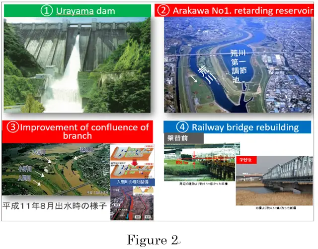

Arakawa No.1 retarding reservoir controls Flood and Supply water to urban area. Speaker shared his experience of working on the same project and he said that he was the in charge of planning and implementation team of this project at site, during its construction which started in 1980 and finished in 1996.
Arakawa No.1 reservoir is an excavated reservoir with the area of 5.8 km2and the flood capacity of 39 million m3. This reservoir has the ability to reduce the flood flow rate up to 850 m3/s. For flood control of Arakawa, overflow dike was also lowered to allow overflow into the reservoir when the water level exceeds from a certain limit. The surface of this dike is covered with thick asphalt (about 50 cm) to prevent overflow collapse.
He conversed that even though the flood control facilities in Arakawa are in progress but still there are possibilities of flooding of same scale as it was during the Kathleen typhoon, at the location of city center of Tokyo. He described the expected damage in case of the Akabane embankment failure in case of floods. According to him, 110km2 area with papulation of 1.2 million will be inundated and death toll may rise up to 1200. About 147 km length of subway with 17 routes and 97 stations will be affected. He urged that publication and dissemination of hazard map is very important, to mitigate the disaster risks and for effective evacuation plans. MLIT personals are actively considering this fact and are trying to disseminate hazard maps to residents in various ways. Information on near real time such as radar rainfall information, river water level, flood forecast, live image etc. are transmitted through the homepage or data broadcasting on television. The timeline which is the time series action plans is very effective for accurate emergency response at the time of disaster.
The MLIT promotes the formulation of evacuation timelines and evacuation plans in municipalities and promotes implementation of evacuation drills based on these. Other non-structural measures have also been taken such as crisis management and training and strengthening emergency response system in case of disaster.
Talking about flood control measures of small and medium rivers in Tokyo, he informed that these rivers are managed by Tokyo Metropolitan Government.
He stated that in Kanogawa typhoon disaster of 1958, a lots of small and medium rivers were flooded and a wide area of downtown in Tokyo got destructed. This flood damage became the starting point of flood control measures for small and medium rivers in Tokyo. Since than Tokyo has been promoting river improvements for 46 rivers of 324 km length. A rain intensity of 50 mm per hour was considered as a targeting rainfall intensity to adopt measures against floods of small and medium rivers. He explained the Kanda river flood control measures to describe the improvements in small and medium rivers against floods. The population in the catchment area of the river was about 600,000 people and the urbanization rate was about 60%, in around 1955. But later, urbanization rapidly increased and as a result, population in 2005 was about 1.65 million people and the urbanization rate in 2003 reached about 97%. This increase in urbanization has caused the increase in outflow of the rain to the river in catchment. As urbanization progressed, the surface of the land covered with asphalt or concrete and the rain started flowing quickly in the basin and the peak flow rate of the flood became larger. Previously the rain water used to flow slowly in the basin because it used to stored in farms and natural land. This phenomenon has caused frequent flooding in Kanda River. Comprehensive flood control measures has been taken to tackle this situation namely, measures in rivers, measures in basin and non-structural measures. He said that as a measure in the river, River improvement and Construction of flood control reservoirs are implemented. And as measures in basin, retainment of the area to suppress urbanization, conversation of natural land, construction of retarding basin, construction of permeable pavement, infiltration inlet etc. have been taken. Non-structural measures include establishment of warning and evacuation system, strengthening of the flood fighting system and risk communication with residents. Figure 3 shows a schematic diagram of Comprehensive flood control measures.

He said that measures have been taken to utilize everything in the catchment area to store and infiltrate rainwater to suppress flood outflow and its peak. In river improvement, construction was done to enlarge the cross sectional area of the river. He added that construction activities were very difficult because of the very narrow spaces especially in urban areas where houses were densely located along the river way and it was difficult to widen the river width. They adopted the division canal system to mitigate flood damage and to increase the ability of water to flow by using a culvert system under the road. There are parks constructed with the function of a flood control reservoir. There is a flood control reservoirs in the shape of tunnel with an extension of 4.5 km and an inside diameter of 12.5 m under the road, and stores about 540,000 m3 of floods of the Kanda River. Figure 4 shows the above mentioned examples.

He said that at the time of Typhoon No. 16 in 2004, there was a rain of approximately the same size as the Typhoon No. 11 in 1993 which brought about a lot of flooding damage in the middle Kanda River basin but due to the effect of this reservoir and the improvement of the river, flooding damage was greatly reduced.
He delineated that in recent years, heavy rain downpour exceeding 50 mm/h have been increased and he explained that 50 mm/h is planned target rainfall. He presented the fact that most of the flood damages in recent years are caused by rainfall which exceeds from 50 mm/h. He talked about the flood damages which occurred in 2005. According to him, 8 rivers were flooded due to the torrential rains exceeding 100 mm/h and about 6000 houses were inundated. He spoke about the Effects of measures against floods targeting 50 mm/h and said that the number of inundation damaged houses in the past 30 years steadily declined with the progress of river improvement but however, in recent years, due to the frequent occurrence of rainfall exceeding 50 mm/h flood damage has been increased. He argued that in order to cope with the frequent occurrence of torrential rain of recent years, the current plan is insufficient. He introduced a new flood control policy which was formulated with goal of preventing flood damages against rain fall of 75 mm/h. He further explained that 65 mm/h rain fall is dealt by measures in rivers and sewers and in particular improvement of rivers and construction of flood control reservoirs. For the part of 10 mm/h rain fall, measures in basin are taken such as permeable pavement, infiltration inlet and infiltration gutter. He informed that measures for parts beyond 50 mm/h are accommodated by flood control reservoirs and infiltration measures (public spaces such as under the road and parks are efficiently used). In order to cope with the local concentrated torrential rain which has been increasing in recent years, several underground flood control reservoirs are connected by a tunnel and mutual utilization across the watershed. He presented the example of a regulating reservoir using a tennis court and local government school ground use, as a flood control storage (figure 5).

He said that as a measures in basin Tokyo Metropolitan Government has adopted permeable pavements while updating the pavement of the sidewalks and nowadays many sidewalks are permeable pavements in Tokyo. He also showed the infiltration facilities such as Infiltration inlet and infiltration trench (figure 6).

He added that measures such as publication and dissemination of hazard map and development of a system to provide disaster information to residents are also being promoted.
In the summary of measures against small and medium rivers he told that previously, river improvement were conducted targeting the rain of 50 mm/h and with this measure, flood damage could be reduced but however, frequent flooding happened due to the rain exceeding this limit therefore Flood control measures for 75 mm/h (65 mm/h in the suburbs and 10mm/h in basin) have been formulated. Due to the fact that it is difficult to further widen the river channels due to congestion in urban areas, construction of flood control reservoirs, Rainwater storage, Infiltration in basin and enhancement of warning and evacuation system are being advanced.
While summarizing the whole discussion he said that Tokyo has greatly developed through measures against floods, storm surges and earthquakes over the years. However, it is necessary to continue measures against flood control using all means. In his conclusion he said, “The flood control measures are investment, not cost. For sustainable development, it is indispensable to take preventive structural and non-structural measures. After a disaster, it is important not to recover to the same state as the former, but to build back better, based on lessons learned from the disaster.”